Share This Article
Sudbury has released the public review draft of its 2026–2036 Open Space and Recreation Plan (OSRP), establishing a roadmap for the town’s natural resources, active parklands, trail networks, and municipal investments over the next decade. Developed in collaboration with the BSC Group, municipal staff, local boards, and community feedback, the updated plan re-establishes Sudbury’s eligibility for State grant funding while outlining action steps for balancing conservation with recreation. Here are five highlights from the plan:
A Town Defined by Its Public Lands
One of the draft plan’s most striking revelations is the sheer scale of Sudbury’s protected landscape. Across the town’s 24.4-square-mile area, municipal agencies, state authorities, federal entities, and non-profits like the Sudbury Valley Trustees hold stewardship over thousands of acres of contiguous forest, working farms, and wetland corridors. Nearly 30% of the town, totaling 4,795 acres, is classified state-wide as BioMap Core Habitat, with over 3,455 of those acres permanently protected.
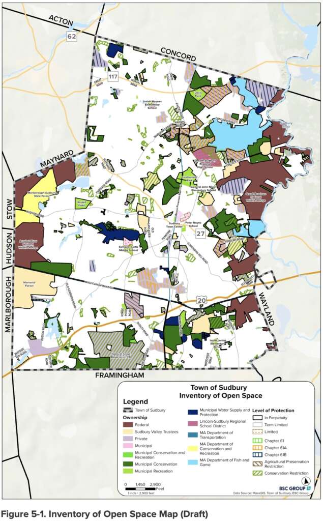
This conservation network is supported by sustained and ongoing local investment. Sudbury was among the first Massachusetts municipalities to adopt the Community Preservation Act (CPA) in 2002. Over the last ten years alone, the town committed nearly $6.2 million in CPA funding toward direct land preservation and improvements, bringing historic signatures like Broadacres Farm under municipal care.
The plan identifies substantial recent and active CPA investments in recreation including:
- CPA-funded improvements to the SMILE Playground at Haskell Field.
- CPA-funded restroom renovations at Haskell Field.
- CPA-funded design of recreation improvements at Davis Field.
- CPA-funded design of recreation improvements at Broadacres Farm and Featherland Park.
- CPA-funded recreation improvements at Feely softball fields.
The Diamond Is More Than An Intersection
Beyond quiet woods and preserved farmland, Sudbury’s open space footprint has evolved into an active regional transportation corridor. The official opening of the town’s central rail-trail infrastructure positions Sudbury as a MetroWest hub for non-motorized travel.
The north-south Bruce Freeman Rail Trail (BFRT) and the east-west Mass Central Rail Trail (MCRT) now intersect at the historic Diamond Crossing near Route 20. The plan describes it as a “defining feature of
Sudbury’s recreation and transportation network.” The plan emphasizes connecting this regional backbone directly to local assets, including Davis Field and the Fairbank Community Center campus.
Those connections would allow residents to travel safely across town without relying on automobiles. The plan also calls for implementation of a Sidewalk Prioritization Plan, which is a big part of the “connections” to the rail trails that are described in the plan. Sidewalks were identified as the top park and recreation priority for residents in the initial survey, and have been a hot topic in Sudbury in recent years.
Addressing the Playing Field Pinch
While passive conservation remains a town trademark, active recreation facilities face significant operational strain. Drawing on the 2025 Town-Wide Athletic Field Evaluation and Needs Assessment, the OSRP notes that 15 of Sudbury’s 33 active recreation areas exceed their recommended capacity of 200 to 250 team uses annually.
High-demand venues such as Featherland Park, Frank Feeley Field, and Haskell Field suffer from heavy compaction and inadequate turf recovery time. To address these shortfalls, the OSRP Action Plan outlines targeted relief measures:
- Upgrading lower-performing diamonds and rectangular fields at Davis Field, Broadacres Farm and Parkinson Field.
- Executing critical drainage overhauls at Frank Feeley Field to prevent seasonal rainwater lockouts.
- Coordinating with Sudbury Public Schools to rehabilitate their playing fields
- Implementing a comprehensive athletic field maintenance plan that addresses resting, overseeding and aeration
Green Infrastructure vs. Climate Realities
The 2026–2036 plan incorporates data from Municipal Vulnerability Preparedness (MVP 2.0) initiatives and custom inland flood modeling projected through 2050 and 2070.
Rather than viewing open space solely through a scenic lens, the document treats natural features as active climate infrastructure. Sudbury’s primary flood storage basins, including the Sudbury River corridor, Great Meadows, Pantry Brook, and Hop Brook Marsh, absorb extreme precipitation, reducing downstream stormwater damage. Similarly, natural turf fields and continuous tree canopies help cool urban heat islands, particularly along commercial corridors like Route 20.
The plan also prioritizes protection of local farmland and areas with Prime Farmland Soils. The heavy agricultural focus in the action plan also calls for greater support for local farmers, including promotion of locally grown foods and additional farm stands. The climate change focus extended to agriculture, highlighting the need to mitigate emerging threats including “climate change, development pressures, and invasive species such as the Spotted Lanternfly and Japanese hops.”
Designing for the Whole Community
Demographic shifts have reshaped how local parks are designed. Older adults (65+) now represent 16% of Sudbury’s population, while more than 1,000 residents reported having a disability on the U.S. Census. Equity extended to financial constraints too.
The plan noted “Sudbury has a median household income of approximately $236,250 and an overall poverty rate of about 3%. Although poverty levels are relatively low, approximately 7% of residents age 65 and older were living below the poverty level in 2024.” That provided the basis for ensuring access for all: “Maintaining free or low-cost recreational opportunities, parks, trails, and community spaces helps ensure residents of all incomes, particularly older adults living on fixed incomes, can continue to benefit from outdoor recreation and community amenities.”
In response, the plan translates the town’s ADA Transition Plan for Parks into concrete physical improvements for all ages:
- Installing smooth circuit walking paths at Haskell Field and ADA-compliant connections linking the MCRT to Duck Pond in the Hop Brook Conservation Land.
- Upgrading the SMILE Playground at Haskell Field with sensory play elements, adaptive swings, and shade structures.
- Expanding accessible restrooms, seating benches, and water refill stations across heavily trafficked parks.
How to Have Your Say
The publication of the draft OSRP initiates a public comment window where residents can review the goals, critique the 10-Year Action Plan, and recommend local adjustments.
The Town of Sudbury invited the community members to submit feedback through the following channels:
- Review the Full Draft: Copies of the draft plan, natural resource maps, and survey breakdowns are available online via the Town of Sudbury Planning & Community Development Department website and in hard copy at the Goodnow Library and Town Offices (Flynn Building). (PDF HERE)
- Written Comments: Written feedback, suggestions, or corrections can be emailed to the Planning & Community Development Department. (More info HERE)
- Public Meetings: The Town will host a public input session on October 15 at the Fairbank Community Center. (Details HERE)